Can CMIP5 models simulate the influence of different types of ENSO on South American precipitation?

A recent study (Tedeschi & Collins, 2015), published by International Journal of Climatology, investigates how 35 CMIP5 models simulate South American precipitation anomalies under the influence of different types of El Niño-Southern Oscillation (ENSO). The observed precipitation in South America exhibits significant anomalies when there are strong sea surface temperature anomalies (SSTA) in different parts of equatorial Pacific. The study analyses how models simulate these influences in present day climate simulations.
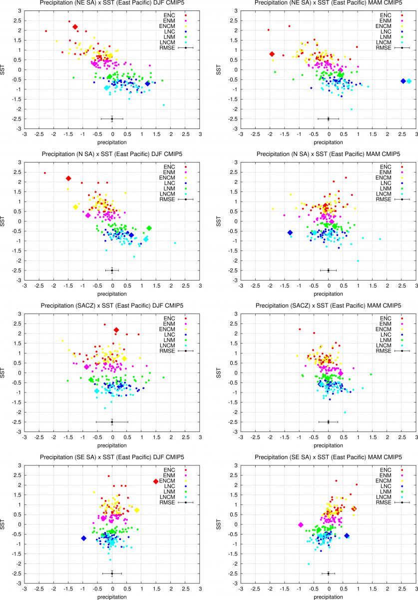
The CMIP5 models can simulate the basic structure of SSTA during different types of ENSO, albeit with some spatial errors. When South American precipitation during all ENSO categories is analysed (Figure 1), it is possible to see that the sign of anomalies is well represented in both the northeast South America during austral summer and autumn, and in north South America during austral summer. These anomalies occur because the teleconnections, via a modified Walker circulation, are relatively strong. However, the models that better simulate the precipitation in tropical South America are different from those that can represent the precipitation in central and southeast South America. Many CMIP5 models have difficult in representing the sign of precipitation, during austral summer and autumn, in central-east and southeast regions of South America during different types of ENSO events. However, during austral autumn, the precipitation in southeast South America does show some relationship with the zonal wind at 200 hPa in the equatorial Pacific, which is linked to Rossby wave trains emanating from the equator.
Written by Renata G. Tedeschi and Matthew Collins
The influence of ENSO on South American precipitation during austral summer and autumn in observations and models (International Journal of Climatology)
1College of Engineering, Mathematics and Physical Sciences, University of Exeter, UK
(Article first published online: 19 MAY 2015)

Figure 1: Scatter plots of SST composites in the East Pacific versus composite precipitation in NE South America (1st line), North South America (2nd), SACZ (South Atlantic Convergence Zone) (3rd) and SE South America (4th), during DJF (1st column) and MAM (2nd). Each dot represents the composite computed over one historical simulation from the CMIP5 archive. The diamonds are the composites obtained from the observed data. The horizontal black line represents the root mean squared error on the composite precipitation computed from those models in the CMIP5 archive that have multiple members with different initial conditions.


